Allow me to set the scene: it’s a Sunday, the curtains are drawn, the bed is as comfy as ever. Wally‘s lounging around with us, the coffee is delightful, and all paths look to lead to a lazy day.
Then, the planning came. We do this often—Chad will do some research and pluck out a hike that sounds appealing. This time, he mentioned that we could go for a quick hike next week. Linkins Lake Trail while short, was rocky and steep and would lead to a high-alpine lake at 12,000 ft. in elevation.
“Why not go now?” I asked. So, we did.
Spontaneity is not really our thing. So this spur-of-the-moment plan was an exciting and fun and a little out of our comfort zone, especially with a new hike in a place we’d never been.
On the road

We chose a trail located on Colorado’s Independence Pass (Linkins Lake Trail hike), which is known for its panoramic mountain and valley views. The pass is accessible through the city of Aspen, and takes drivers on a winding road that is narrow and right on the edge of a very steep overlook.
This is one of the most scenic drives in all of Colorado, so it gets busy. It’s a little scary, to be honest, with several curves and not a lot of lane space. It’s not so bad when it’s just your car zipping through, but traffic and side-street parking and bicyclists increase the hazard. This is just good to note if you’re planning to visit.
The views, however, make up for the white-knuckle moments. If you continue on Independence Pass, you’ll wind up near Buena Vista, Colorado. If you drive west some ways from Buena Vista, you’ll wind up in my hometown of Gunnison. (Just a fun fact for ya!)
To the trail
We were thankfully able to find parking at the Independence Lake Trailhead, at a particularly scenic point of the pass.
After unloading Wally and our slightly over-packed gear, we hit the trail, which began inclining right away. As it happens, the scenic views were vibrant before setting foot on our hike. It was mind-blowingly beautiful, everywhere.
Linkins Lake Trail Hike
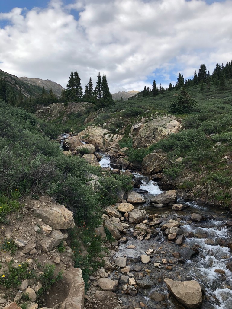
From the get-go, the Linkins Lake Trail hike is stunning. There’s a babbling creek, snow-capped peaks in the distance, and a field full of green. You’re surrounded by incredible views: in front, to the sides, and even behind. The highway is even picturesque, and doesn’t disrupt any photographs.


The trail begins to incline right away. It’s short, but it’s effective. We were breathing heavy and realized that maybe we’re not in the best shape, but the beauty distracted ourselves enough to make it really, really fun.
We took several breaks to pull off to the side when other hikers came past. This was mainly to keep Wally calm (other people and doggos are super exciting to him) and give him a break (it was only his second hike ever), but it also acted as a way to social distance. Honestly, it was nice to catch my breath too.
There are several stretches of the trail that involve rocky terrain. Though I was initially worried about Wally making it up, he cruised right through with no difficulty. That being said, he also went a little too fast for us on the way down. Going downhill, it was important for me and my knees to keep an easy pace.


At the lake
After about half a mile or so, Chad, Wally, and I were rewarded with an alpine lake. Linkins Lake, for which the trail is named, was a beautiful sight. Since it was overcast and threatening to storm, the water reflected the skies; most days, however, it’s known to have a gorgeous blue and turquoise hue.

There was one other group there, and they were on the water with canoes, fishing rods, and a stand up paddleboard. We walked quite a ways to a more private area, and sat down on some rocks to eat our prepped wraps and sip our water. Wally ate a few puppy treats, while we thought about cracking our beers. (We ultimately didn’t, because the storm was rolling in quickly and we didn’t want to be caught up in it, especially with lightning.)

We walked along the shore, posed for some photos, and tried to get Wally to wade in the water. (He was not about it.) (Yet.) Though it was a quick rest at the top, our time spent at the lake gave us a boost of energy to head back down.


I took numerous photo stops along the way and couldn’t help but feel like the luckiest person alive. All of this, practically in my backyard? An unexpected Sunday adventure, spent with my two besties? As we wandered back to the car, I had two main thoughts: first, I love this adventuring family we’ve built; and second, I promised to return to this gorgeous spot.


Hike pros:
- Scenic, amazing, outstanding views
- Short and sweet
- Alpine lake waiting at the top
- Dogs (on leash) are welcome
- Nearby Aspen, so you can spend some time in the town after
- Must-do Aspen trail (in my opinion)
Hike cons:
- It’s quite rocky and steep (kids probably can do it, but it’d take a while I think)
- Parking is a little dicey, and very close to the pass. Independence Pass is extremely popular (for good reason), so might be hard to find parking at certain times.
- Super popular trail (for good reason), so might be hard to find parking at certain times
- The altitude is high and the elevation gain is noticeable; out-of-towners should be aware and adjust to the altitude before heading on this trail.
My Overall Rating: 5/5 Stars

Trail information
Length: 0.5 miles
Type: There and back
Difficulty: Moderate/intermediate
Elevation gain: 528 feet
Usage: Moderate to high
Dogs Allowed: Yes
More information: Alltrails.com
Hiking notes: Please take into consideration the elevation; not only are you starting at 12,000 ft, there’s a quick incline and gain. Prepare by drinking water and adjusting to avoid altitude sickness.
Also: this hike is located on one of Colorado’s busiest scenic drives. The parking lot fills quickly, and it’s not advised to park on the side of the road. Try to avoid high-traffic times and days.

Established in 2018, Sunshine with Savannah is a catch-all blog with an emphasis on weekend travel, millennial-style marriage and fun, reflection-based musings, outdoor adventure, home design, and all things lifestyle.
Though the content is diverse and varied, the heart of this space stays true to a single, guiding principle: a simple pursuit to find sunshine, wherever I go.
What a terrific hike, and Wally is the perfect companion as well! Thanks for sharing this great photos, nature showing up in all its glory!
He’s a great little trooper for sure! Thank you so much for reading and commenting.